
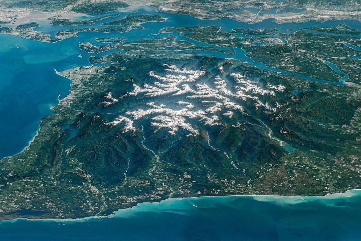
The rugged interior of the Olympic Peninsula, a remote bastion of wilderness in the northwestern corner of Washington state, is showcased in a stunning, composite image captured by an astronaut aboard the International Space Station. This oblique view, taken on May 6, 2016, offers a breathtaking panorama of a landscape defined by its dramatic alpine glaciers, wild coastlines, ancient temperate rainforests, and the deep river valleys that define its mountainous core. The Olympic National Park, a UNESCO World Heritage Site, encompasses much of this dramatic terrain, protecting not only the imposing Olympic Mountains but also significant stretches of the Pacific coastline. The surrounding areas are a mosaic of national forests, state-owned lands, and tribal territories, underscoring the region’s diverse stewardship.
A Geological Tapestry Forged by Ancient Seas and Tectonic Might
The geological narrative of the Olympic Mountains is one of immense scale and time. The very rock that forms these imposing peaks originated not on land, but deep beneath the ocean’s surface. Between approximately 55 and 15 million years ago, layers of basalt, the molten rock from underwater volcanic eruptions, accumulated on the ocean floor. These basaltic layers were further augmented by sediments of sand and mud, transported seaward by powerful river systems over millennia. This oceanic accretion formed the foundation for what would become a mountain range.
The dramatic uplift of these seafloor deposits is a direct consequence of plate tectonics. As the oceanic Juan de Fuca Plate subducts, or slides beneath, the continental North American Plate, the layers of rock on the ocean floor are scraped off and intensely folded. This immense geological process, akin to a colossal bulldozer pushing material upwards, has sculpted the Olympic Mountains, raising them to elevations of up to 8,000 feet (2,440 meters) above sea level. This ongoing tectonic activity continues to push the mountains upward, a testament to the dynamic forces shaping our planet.
The Sculpting Power of Ice and Water: Glaciers and River Valleys
While tectonic forces drive the mountains skyward, the powerful forces of erosion, fueled by the region’s abundant precipitation and snowfall, work in tandem to sculpt its dramatic topography. Snow accumulating at higher elevations feeds the alpine glaciers that are a defining feature of the Olympic range. These glaciers, acting as slow-moving rivers of ice, relentlessly carve into the underlying rock, deepening valleys and shaping the mountainsides.
However, the geological narrative is also one of change. Studies have indicated a concerning trend of glacial retreat and thinning across the Olympics. Data collected in 2015 identified approximately 255 glaciers and perennial snowfields in the range. Alarmingly, a subsequent analysis revealed that 35 glaciers and 16 perennial snowfields had completely disappeared in the preceding 35 years, a stark indicator of the impacts of a warming climate. This observed loss of glacial mass has implications for water availability in the region and the unique ecosystems that depend on these icy reservoirs.
The erosive power of water is equally evident in the deep, radiating river valleys that descend from the snowy peaks. Prominent among these are the Hoh, Queets, and Quinault rivers, which drain westward into the Pacific Ocean. These verdant valleys are renowned for their exceptionally rich temperate rainforests, ecosystems characterized by towering trees, dense undergrowth, and a perpetually damp, moss-laden environment. The ancient forest within the Hoh River valley, in particular, has been recognized for its profound natural quietude, once considered among the most undisturbed places in the United States, free from the pervasive hum of human-generated noise.
The Elwha River: A Story of Restoration and Resilience
Flowing northward, the Elwha River carries a profound natural and human history. Its valley served as a pathway for some of the earliest Euro-American explorations of the Olympic Peninsula. A notable expedition, sponsored by a Seattle newspaper, traversed the mountain range from north to south between December 1889 and May 1890. The journey, which involved ascending the Elwha valley and descending the Quinault, was significantly hampered by an unusually harsh and snowy winter, forcing the party to spend several months within the Elwha Valley.
In the early 20th century, the Elwha River’s potential for economic development became apparent to entrepreneurs. Two dams were constructed on the river, harnessing its power to fuel local industries. However, these engineering feats came at a significant ecological cost. The dams effectively blocked the migratory pathways of once-abundant salmon and trout populations, preventing them from reaching their ancestral spawning grounds.
Recognizing the ecological damage, a monumental restoration effort was launched. In 2011 and 2014, the Elwha and Glines Canyon dams were removed in what was, at the time, the largest dam removal project in the United States. This ambitious undertaking marked a pivotal moment in river restoration, initiating a complex process of ecological recovery. The subsequent years have seen dedicated efforts to re-establish native fish populations, reseed and cultivate native plant communities along the riverbanks, and replenish sediment deposits crucial for the river’s natural functioning. The ongoing restoration of the Elwha River stands as a powerful testament to the potential for ecological healing and the importance of restoring natural river systems.
Gateway to the Salish Sea: Waterways and Connectivity
The mouth of the Elwha River forms a delta that empties into the Strait of Juan de Fuca, the significant waterway that borders the peninsula to the north. This strait, a vital maritime channel, serves as the boundary between the United States and Canada, with Vancouver Island in British Columbia lying to the north. The Strait of Juan de Fuca is a critical link, connecting the vast Pacific Ocean to the Salish Sea, which includes the Strait of Georgia and Puget Sound.
This waterway is a major artery for global commerce, utilized by ships accessing important West Coast ports such as Seattle and Tacoma. These bustling urban centers are visible in the upper right portion of the astronaut’s photograph, appearing as clusters of light against the natural landscape. The continuous flow of maritime traffic underscores the strategic importance of this coastal region and its interconnectedness with global trade routes.
A Legacy of Exploration and Environmental Stewardship
The Olympic Peninsula’s rich history is interwoven with exploration, resource utilization, and an evolving understanding of environmental stewardship. From the arduous expeditions of the late 19th century to the industrial development of the early 20th century and the large-scale dam removals of the 21st century, the region’s narrative is one of continuous adaptation and transformation. The astronaut’s photograph, therefore, is more than just a visual representation of a stunning landscape; it is a snapshot of a dynamic environment shaped by geological forces, natural processes, and human endeavors. It highlights the ongoing efforts to balance human needs with the imperative of preserving the region’s unique ecological heritage for future generations. The image serves as a powerful reminder of the intricate beauty and ecological significance of the Olympic Peninsula, a place where the wild heart of nature continues to beat strongly.
The astronaut photographs ISS047-E-104138 through ISS047-E-104144 were acquired on May 6, 2016, using a Nikon D4 digital camera with a 400-millimeter focal length. These images were provided by the International Space Station’s Crew Earth Observations Facility and the Earth Science and Remote Sensing Unit at NASA Johnson Space Center. The photographs were taken by a member of the Expedition 47 crew. To enhance clarity and detail, the images have undergone cropping and contrast adjustments, and lens artifacts have been meticulously removed. The International Space Station Program supports this initiative as part of the ISS National Lab, enabling astronauts to capture Earth imagery of significant value to scientists and the public. These images are made freely available online. A broader collection of astronaut-captured images of Earth can be accessed through NASA/JSC’s Gateway to Astronaut Photography of Earth. This report was compiled by Lindsey Doermann.