
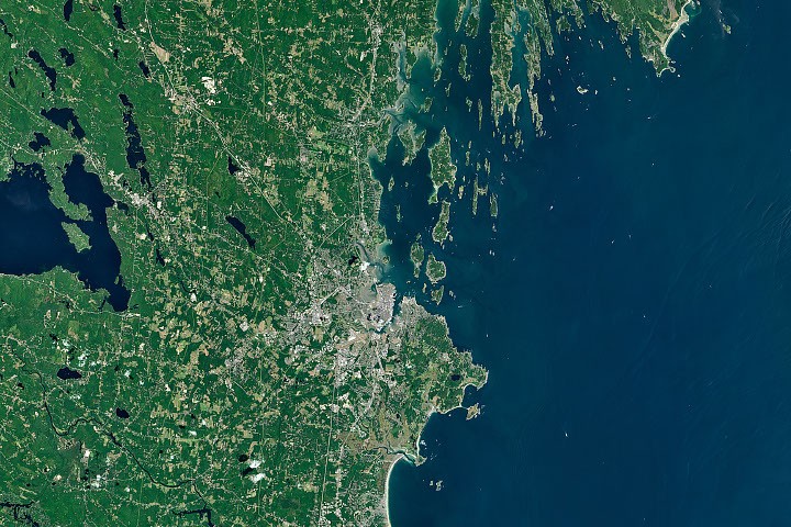
The coastlines west of Portland present a starkly different appearance from those northeast of the city, a divergence sculpted by the intricate interplay of underlying bedrock and the historical distribution of sediments deposited by ancient glacial activity. This dramatic geographical transition, vividly captured by NASA’s Landsat imagery, offers a compelling case study in how geological processes can shape landscapes and influence regional economies.
Echoes of Ancient Myths and Modern Science
For centuries, the Wabanaki people have woven rich creation myths to explain the dramatic, rocky shores of the Bay of Fundy, Downeast Maine, and Acadia National Park. These ancestral narratives often feature Glooscap, a powerful, mythical figure credited with shaping the rugged coastlines. Legend tells of Glooscap navigating the Bay of Fundy in a stone canoe, carving out bays and inlets by scraping its hull across the land, and scattering immense boulders during epic battles with mythical creatures like primordial beavers, frogs, moose, and whales. These stories, passed down through generations, offer a cultural lens through which to understand the formidable beauty of these eastern regions.
In contrast, fewer Indigenous creation stories are specifically documented for the sandy and marshy shorelines of southern Maine or the intricately indented coasts of the state’s Midcoast region. However, the visible contrast between the soft, sandy expanses south of Portland and the hard, rocky promontories, headlands, and narrow peninsulas to the east has long fascinated coastal geologists. Their scientific explanations, grounded in empirical observation and data, illuminate the geological forces at play.
The Geological Divide: Bedrock and Glacial Legacy
Coastal geologists attribute the distinct character of Maine’s coast to two primary factors: variations in the underlying bedrock and the distribution of sediments left behind by the last glacial maximum.
Southern Maine: A Canvas of Sand and Salt Marsh
South of Portland, the landscape is characterized by extensive deposits of sand, much of which was transported by rivers. A prime example is Saco Bay, home to Maine’s longest contiguous beach and its largest salt marsh. Peter Slovinsky, a geologist with the Maine Geological Survey, explains that the sediment forming these sandy shores originated from the weathering and breakdown of rocks in the White Mountains. This material was then carried to the coast, predominantly by the Saco River. Over millennia, the relentless action of waves and tides has reworked these fine sediments, shaping them into the characteristic arch-shaped embayed beaches and sprawling salt marshes that define the region around Saco Bay.
While erosion-resistant granite formations do emerge along the southern coast, creating rocky headlands that punctuate the sandy expanses, they represent a transitional feature.
Midcoast and Eastern Maine: The Dominance of Metamorphic Rock
East of Portland, the geological narrative shifts dramatically. Here, metamorphic bedrock becomes the dominant surface feature. These ancient rock layers, transformed by immense pressures and high temperatures over geological time, form distinct ridges and valleys that define the topography. During the last ice age, colossal glaciers, including the Laurentide Ice Sheet, scoured and widened many of these pre-existing coastal valleys. As the ice sheet eventually melted and global sea levels rose, these enlarged valleys were inundated by the ocean.

Nicholas Whiteman, another geologist with the Maine Geological Survey, elaborates on the impact of these geological formations. "The tortured folds of these old landscapes also set up a sharp directional preference for erosion to exploit," Whiteman states. "This led to the eye-catching difference in the orientation of the islands and necks that dominate Casco Bay compared with those to the northeast."
This geological history is particularly evident around Casco Bay, where the combination of submerged ridge-and-valley systems and the drowned coastline creates the region’s characteristic jagged, highly indented shoreline and numerous long, narrow islands.
Economic Ramifications: From Tourism to Fisheries
The stark differences in Maine’s coastal geology are not merely academic; they have profound implications for the state’s economy, influencing everything from tourism to its iconic natural resource industries.
Tourism and Recreational Beaches: The sandy beaches of southern Maine, like those in Saco and Kennebunkport, are magnets for tourists seeking sun, surf, and relaxation. The accessibility and expansive nature of these beaches make them prime destinations for summer vacationers, contributing significantly to the local economies of these communities.
The Lobster Capital: Midcoast’s Rocky Embrace: Conversely, the state’s world-renowned lobster fisheries are heavily concentrated in Midcoast Maine. The complex network of rocky inlets, protected bays, and sheltered waters in this region provides ideal habitats for the cold-water crustaceans. Communities such as Harpswell have become leading centers for lobster landings, a testament to the symbiotic relationship between the environment and this vital industry. The intricate coastline offers natural protection for fishing vessels and facilitates the traditional methods of lobster trapping.
Oyster Farming’s Niche: The Midcoast region also plays a crucial role in Maine’s burgeoning oyster farming industry. Sheltered bodies of water like Casco Bay and the Damariscotta Estuary offer calm conditions, allowing farmers to cultivate oysters without the need for large, expensive boats. These diverse aquatic environments provide a spectrum of temperatures, salinities, and other characteristics that foster numerous microclimates. These unique conditions allow oysters to grow rapidly and develop distinct flavors, a phenomenon known as "merroir," which is analogous to terroir in winemaking.
Researchers at the University of Maine, including Tom Kiffney, are leveraging satellite data from Landsat and other Earth observation platforms to enhance oyster farming operations. Their work aims to predict oyster growth rates and identify optimal locations for new farms by analyzing water temperatures and quality, demonstrating how modern scientific tools can support and advance traditional industries.
A Landscape Forged by Time and Transformation
The visual dichotomy of Maine’s coastline—the soft, sandy stretches of the south giving way to the rugged, island-studded shores of the east—serves as a powerful reminder of the dynamic forces that have shaped our planet. From the mythical tales of Glooscap to the precise measurements of geologists and the sophisticated analyses of satellite imagery, the story of Maine’s coast is one of geological evolution, glacial legacy, and the enduring connection between the land and the people who inhabit it. This striking natural division not only offers breathtaking vistas but also underpins the distinct economic and ecological identities of the communities that call Maine home.