
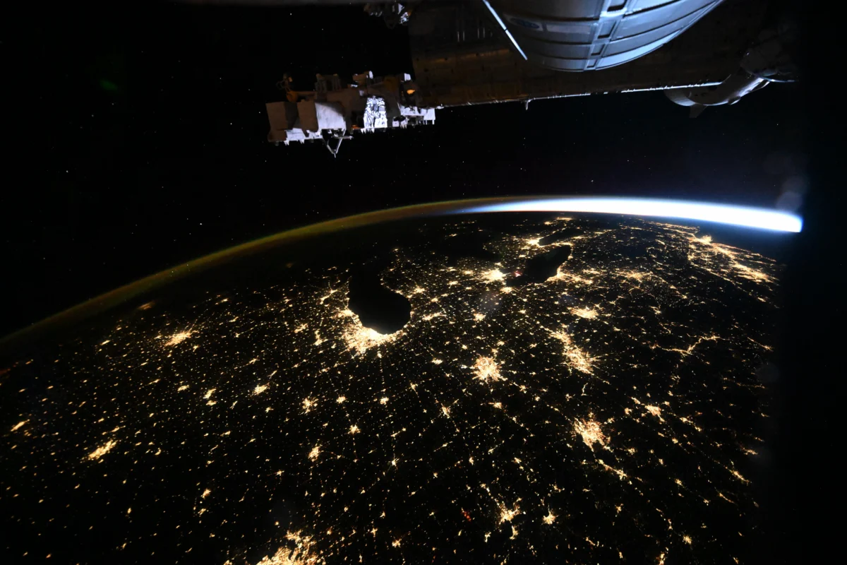
A bird’s eye view of the American Heartland and East Coast from the International Space Station provides a rare, luminous perspective on the scale of human infrastructure as seen from low-Earth orbit. Captured on October 18, 2026, by Canadian Space Agency (CSA) astronaut Joshua Kutryk, the photograph highlights the expansive reach of urban electrification stretching from the industrial centers of the Midwest to the densely populated corridors of the Atlantic seaboard. At the time the image was recorded, the International Space Station (ISS) was orbiting at an altitude of approximately 259 miles, documenting the pre-dawn glow of major metropolitan hubs, including Chicago, Detroit, and the New York City region.
The Technological Significance of Orbital Photography
The photograph serves as more than a striking visual representation of North America; it acts as a critical data point for researchers studying light pollution, energy consumption, and urban expansion. Capturing these images from the ISS requires precise timing, specific camera configurations, and an understanding of orbital mechanics. Astronauts onboard the station frequently utilize high-resolution digital cameras equipped with long-lens optics to document Earth’s surface.
These images allow scientists to track the growth of "light footprints," which serve as a proxy for urban development and economic activity. By comparing current imagery with historical archives dating back to the early years of the ISS, researchers can observe how shifts in population centers and changes in lighting technologies—such as the transition from high-pressure sodium lamps to light-emitting diodes (LEDs)—affect the overall luminous output of American cities.
Chronology of the Mission and Imaging Event
The capture of this image occurred during the mid-autumn period of 2026, a time when orbital conditions were optimal for night-side observation over the North American continent. The following timeline outlines the operational context surrounding the photograph:
- September 2026: Crew members aboard the ISS, including CSA astronaut Joshua Kutryk, begin a series of Earth observation training sessions focused on documenting atmospheric phenomena and human-made landscapes.
- October 18, 2026, 03:45 UTC: The ISS reaches a position directly above the central United States, providing a clear, cloudless view of the Midwestern industrial heartland.
- October 18, 2026, 03:52 UTC: Astronaut Joshua Kutryk executes the photograph, utilizing the Cupola module’s panoramic view to frame the lights of Chicago, Detroit, and the East Coast corridor before sunrise.
- October 20, 2026: The image is transmitted via the Tracking and Data Relay Satellite System (TDRSS) to ground stations, where it undergoes preliminary processing by NASA’s imaging team.
- November 5, 2026: NASA and the CSA officially release the high-resolution image to the public, documenting the specific visual data regarding the urban sprawl of the United States.
Supporting Data on Urban Infrastructure
The regions captured in the image represent some of the most concentrated areas of energy usage in the world. The Chicago-Detroit-New York corridor functions as an interconnected economic powerhouse. Data from the U.S. Energy Information Administration (EIA) notes that these regions consume a significant portion of the national electricity grid, particularly in the pre-dawn hours when industrial processes are active and early-morning commuting patterns begin to manifest in the form of illuminated highway networks.
The "light footprint" visible in the image correlates strongly with population density. According to U.S. Census Bureau estimates, the Northeast Megalopolis—the continuous urban area stretching from Boston to Washington, D.C.—remains the most densely populated region in the country. The visual evidence of these lights from space confirms the ongoing trend of horizontal urban sprawl, as the illumination extends deep into suburban and exurban areas, connecting the major hubs into a singular, glowing network of human activity.
Perspectives from Space Agencies
While official statements regarding specific photographs are often brief, the implications of such imagery are frequently discussed within the context of international cooperation. Astronauts like Joshua Kutryk serve as the eyes of humanity in space, providing essential visual data that remote-sensing satellites sometimes miss due to fixed orbital paths.
"Earth observation is one of the primary pillars of our work aboard the ISS," remarked a spokesperson for the Canadian Space Agency. "When our astronauts capture these images, they aren’t just taking pictures; they are capturing the history of our planet’s development. These images provide a unique context for geographers and urban planners who are trying to understand how our footprint on the Earth is changing over time."
NASA, in conjunction with its international partners, emphasizes the importance of this work for public outreach and scientific literacy. By providing high-quality imagery to the public, the agencies foster a greater understanding of the delicate balance between human progress and environmental impact.
Broader Implications: The Impact of Light Pollution
The visual documentation of these cities has sparked renewed discussion regarding the environmental implications of light pollution. Astronomers and environmentalists have long advocated for "dark sky" initiatives, arguing that excessive nighttime illumination disrupts migratory patterns of birds, affects the circadian rhythms of local flora and fauna, and degrades the human experience of the night sky.
The imagery from October 18, 2026, illustrates the scale of the challenge. As urban areas grow, the light spillover into surrounding natural areas becomes more pronounced. Analysis of this specific photograph by urban planners can help identify areas where "smart lighting" initiatives—such as motion-activated streetlights or directional shielding—might be implemented to reduce unnecessary skyglow.
Furthermore, the imagery serves as a pedagogical tool. By visualizing the density of the East Coast compared to the Midwestern hubs, students and researchers can better grasp the concept of urban geography. The stark contrast between the brightly lit metropolitan centers and the darker, rural gaps between them provides a clear visual demonstration of where the American population is concentrated and how that population interacts with the land.
Future Prospects for Orbital Earth Observation
As the International Space Station approaches its projected end-of-life cycle later in the decade, the focus on Earth observation is intensifying. The documentation of the American landscape from space provides a baseline for future orbital platforms, including commercial space stations and lunar gateway missions.
The transition toward high-resolution, multi-spectral imaging will likely be the next frontier. While the current photograph is a classic visual representation, future missions will likely incorporate sensors capable of measuring the specific wavelengths of light emitted by cities. This would allow scientists to differentiate between various types of lighting, such as high-pressure sodium, mercury vapor, and LED, providing a more detailed look at the energy efficiency of the American power grid.
Ultimately, the image of Chicago, Detroit, and the East Coast remains a testament to human resilience and technological advancement. It serves as a reminder that even from 259 miles above, the reach of human society is unmistakable, luminous, and constantly evolving. Through the lens of astronauts like Joshua Kutryk, the global community gains a necessary perspective on the world we occupy, encouraging a dialogue about how we can manage our resources more effectively as we move toward the middle of the 21st century.
The ongoing commitment to documenting the Earth from low-Earth orbit ensures that we remain connected to the physical reality of our home planet, even as we look toward the stars. Whether used for scientific analysis, urban planning, or simply the appreciation of the world’s beauty, such images remain an indispensable component of the modern space exploration mission.